Mars Has Two Moons
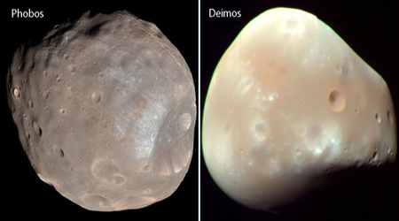
The two moons of Mars, Phobos and Deimos, were discovered by American astronomer Asaph Hall in 1877. He discovered Deimos the first night and Phobos six days later. The planet is named after Mars, the Roman god of war. It was known to the ancient Greeks as Ares, their god of war. Hall named the moons after the sons of the god Ares. Phobos means "fear," while Deimos means "rout." They always show the same face to Mars, just as our moon does to Earth.
Both Phobos and Deimos appear to be made of carbon-rich rock mixed with ice and are covered in dust and loose rocks. They are tiny next to Earth's moon, and are irregularly shaped. (They lack enough gravity to pull themselves into a more circular form.) The widest Phobos gets is about 17 miles, and the widest Deimos gets is roughly 9 miles.
Both moons are pockmarked with craters from meteor impacts. The surface of Phobos also possesses an intricate pattern of grooves, which may be cracks that formed after an impact that created the moon's largest crater — a hole about 6 miles wide. Phobos is gradually spiraling toward Mars, drawing about 6 feet closer to the Red Planet each century. Within 50 million years, Phobos will either smash into Mars or break up and form a ring of debris around the planet. Top
Olympus Mons
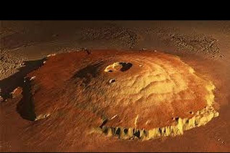
The tallest mountain in all of the "planets" is Olympus Mons on Mars. Olympus Mons is a 13 miles high and is a 375 mile wide volcano roughly the size of Arizona. Olympus Mons was formed billions of years ago. See the 3-D Mons image to the left. Scientists have found a lot of recent evidence of volcanic lava which suggests Olympus Mons may still be active.
Olympus Mons is a shield volcano. Rather than violently spewing molten material, shield volcanoes are created by lava slowly flowing down their sides. As a result, the mountain has a low, squat appearance, with an average slope of only 5 percent.
In comparison, Hawaii's Mauna Loa, the tallest volcano on Earth, rises 6.3 miles above the sea floor (but its peak is only 2.6 miles above sea level). The volume contained by Olympus Mons is about a hundred times that of Mauna Loa, and the Hawaiian island chain that houses the earthly volcano could easily fit inside its Martian counterpart.
Olympus Mons rises three times higher than Earth's highest mountain, Mount Everest, whose peak is only 5.5 miles above sea level. It is the second highest mountain in the entire "solar system", topped only by the Rheasilvia central peak on the asteroid Vesta, which is 14 miles high.
Why such a huge volcano on Mars but not on Earth?
Scientists think that the lower surface gravity of the red planet, combined with higher eruption rates, allowed for the lava on Mars to pile up higher. The earth presence and Mars absence of tectonic plates could also play an important role in the different kinds of volcanoes. The hot spots of lava under the crust remain in the same location on both planets.
On Earth, however, the movement of the crust prevents the steady buildup of lava. The Hawaiian Islands, for instance, formed as a plate drifted over a hot spot. Each eruption created a small island in a different spot.
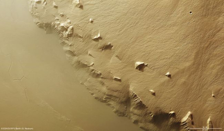
But Mars has very limited plate movement. Both the hot spot and the crust remained unmoved. (See the photo of the eastern flank of Olympus Mons to the left.) When lava flows to the surface, it continues to pile up in a single spot. Instead of a chain of volcanic islands (like the Hawaiian Islands), large volcanoes such as Olympus Mons formed in one place on Mars. Top
Canyon Valles Marineris
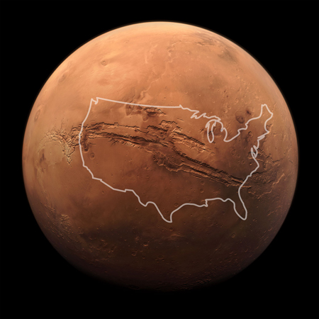
Valles Marineris, named after the Mariner 9 probe that discovered the valley in 1971, is a system of canyons that spans 2,500 miles. At some points, the canyon is 125 miles wide. Regions can reach depths of 6 miles. If the system were located on Earth, it would stretch across the United States, from Los Angeles to the Atlantic coast. See the illustration to the left. By comparison, Earth's natural wonder, the Grand Canyon, is only 227 miles long, 18 miles wide, and 1 mile deep.
The canyon system contains a number of different features that give clues to its formation. Collapsed pits created by rushing water eating away at the land, massive floods, and seeping along canyon walls all point to water just at or beneath the surface at some point in the Martian history. Cracks in the crust, cliffs, walls, and landslides also exist along the expanse of Valles Marineris.
Over the years, scientists have proposed a number of theories about the formation of Valles Marineris. Today, most scientists think that the formation of the Tharsis region may have helped the canyon to form. Tharsis is a vast volcanic plateau centered near the equator in the western hemisphere of Mars. The Tharsis region contains three large volcanoes that dwarf those found on Earth - Arsia Mons, Pavonis Mons, and Ascraeus Mons, which are known as the Tharsis Montes.
As molten rock pushed through the volcanic region to form the monstrous Tharsis volcanoes 3.5 billion years ago, the crust heaved upward. The strain cracked the crust, causing large faults and fractures across the planet's surface. Such fractures, growing over time, gave birth to the enormous canyon system. The spreading cracks caused the ground to sink and opened an escape for subsurface water. The upward rushing liquid broke down the edges of the fractures, enlarging them and washing away more of the ground while flowing past. Top
Water On Mars
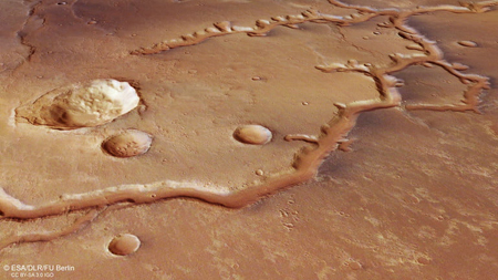
The image to the left is from ESA’s Mars Express and shows a dried up river valley on Mars named Nirgal Vallis located just south of the equator. The river system stretches for nearly 435 miles and was shaped both by the flow of liquid water through the rock and by impacts when meteorites hit the surface. The system is believed to be between 3.5 and 4 billion years old.
Even if we had the technology, we could not drill down to water on Mars. Current international agreements on planetary protection prohibit contact with liquid water on other worlds in order to avoid any type of contamination from Earth.
There is an active discussion about relaxing the restrictions. The highest level of sterilization must be used with the components in contact with water, developing new techniques and protocols if needed. If one wants to find current or previous Martian life, one must be able to interact with liquid water.
Exploration is in the DNA of humankind. However the immense cost of sending humans to Mars requires a consensus between international space agencies and the scientific community. A win-win option for searching for life on Mars and advancing human presence in the solar system looks like a combination of robots and astronauts. Top
Ice Frost At Hooke Crater
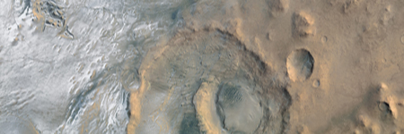
Heavy ice frost deposits coat the ground in and around the 86-mile diameter Hooke Crater in the image to the left. It was named after British physicist-astronomer Robert Hooke. The frost serves as a reminder that Mars still possesses water that moves dynamically between the atmosphere and the surface, mostly in the form of ice and vapor.
At present, Mars has thick water-ice polar caps and icy clouds. In many locations, temperatures get low enough overnight for the relative humidity to reach 100 percent, and frost forms on the ground as water vapor condenses. As water has moved around with Mars’ shifting climate over its long history, there may have been many periods of wetting and drying all over the planet. Some of the sand dunes have gullies on them. While these gullies may be a bit different then ones found on crater walls, they have been thought to be caused by flowing water. Top
Gale Crater
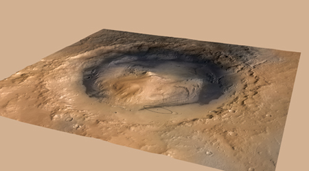
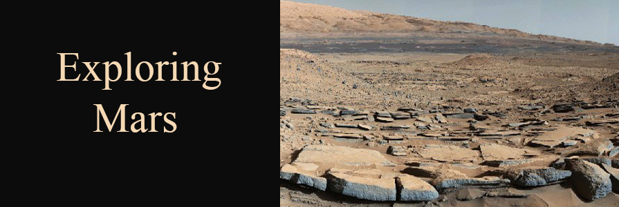
In 2012 NASA's Curiosity Rover landed on Gale Crater, pictured to the left. The actual landing site is the tiny ellipse in the tan area just below the center right of the picture to the left. The Gale Crater is named for Australian astronomer Walter F. Gale (1865-1945). A picture of rocks and other Gale Crater material can also be seen in the Exploring Mars heading at the very top of this page.
Curiosity has collected evidence of an ancient salty lake that once lapped the edges of the Gale Crater some 3.7 billion years ago. Analyzing soil samples collected from the crater's bedrock, researchers from Caltech have turned up a range of salts not observed in other rocks on Mars. Dating back roughly 3.3 to 3.7 billion years ago, the Caltech team proposes that the sulfates were left over from evaporated water, indicating the existence of ancient brines (salty pools) that might have once held tiny forms of life.
Formed by a meteor roughly 3.5 to 3.8 billion years ago, the meteor impact punched a hole in the terrain. The explosion ejected rocks and soil that landed around Gale Crater.
Gale Crater was chosen as the landing site for Curiosity because scientists suspected, even from afar, that it was a dried-up lake bed. It turns out, that wasn't a bad hunch.
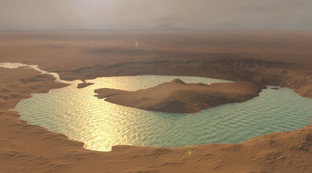
Ever since it landed, Curiosity has strongly supported the lake bed hypothesis. In 2013 NASA announced that Gale Crater once contained an ancient freshwater lake that might have held microbial life. See the artist illustration of the Gale Crater Lake to the left.
In the following years, scientists have noticed even more clues of lakes and streams on the Red Planet. Nevertheless, Gale Crater was the very first time a sulfate-enriched bedrock had been discovered in the sedimentary bottom of a crater. As such, it gave some clues about how Mars might have lost its water long, long ago. Top
Martian Optical Illusion
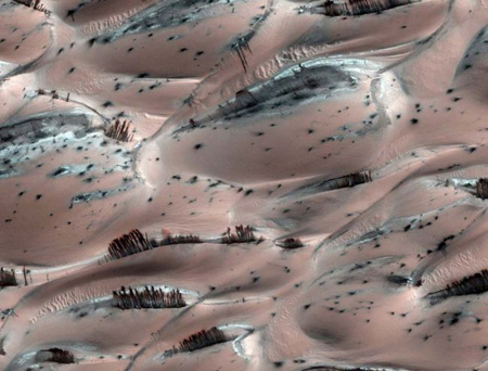
The actual image to the left taken by NASA's Mars Reconnaissance Orbiter demonstrates an optical illusion. Naturally erupting dust clouds on Mars created structures that look surprisingly like trees near the planet's north pole. But don't be fooled – it's just an optical illusion, NASA scientists say.
The Martian "trees" are actually dark basaltic sand pushed to the surface of sand dunes by sun-heated solid carbon dioxide ice, sublimating directly into vapor explains Candy Hansen, a member of NASA's Mars Reconnaissance Orbiter team at the University of Arizona.
The sand dunes form a nearly complete ring around Mars' north pole and are covered by a thin layer of reddish Martian dust and patches of dry ice. In the Martian spring, the sun warms the ice, causing it to sublimate directly into vapor, and the resulting gas dislodges surrounding dust and sand particles.
"What we think is happening is that the dark sand is sliding down the bright frosted portion of the dune," Candy Hansen said. "To date, there is no firm evidence of any type of Martian biology, past or present, plant or otherwise." Top
Actual Mars Landing Sites
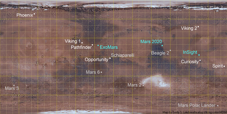
16 Map Landing Locations, Country Of Origin, Launch Date, and Outcome
-
Mars 2 - Russia, May 1971, crash landed on Mars surface
-
Mars 3 - Russia, May 1971, landed safely on Mars surface
-
Mars 6 - Russia, August 1973, contact lost upon landing
-
Viking 1 lander - USA, August 1975, landed and operated successfully
-
Viking 2 lander - USA, September 1975, landed and operated successfully
Pathfinder - USA, December 1996, landed and operated successfully
-
Polar Lander - USA, January 1999, crash landed
-
Beagle 2 - ESA, June 2003, landed successfully, but solar panels failed
-
Spirit - USA, June 2003, landed and operated successfully
-
Opportunity - USA, July 2003, landed and very successful in operation until 2018
-
Phoenix - USA, August 2007, landed and operated successfully
-
Curiosity - USA, November 2011, landed and still in operation
-
Schiaparelli - ESA and Russia, March 2016, crash landed, 5 minutes of landing data saved
-
Insight - USA, May 2018, landed and still in operation
-
Mars 2020 - USA, July-August 2020, now named Perseverance Rover, on schedule as of April 2020
-
ExoMars - ESA and Russia, July 2020, now Rosalind Franklin postponed to 2022 due to parachute issues
** Click Here. to visit the main Mars web site.
Top